
How Laser Mapping Uncovers Hidden Water Problems on Large Properties
Imagine walking across a massive 100 acre property. To your eyes, the land looks perfectly fine. You might spot a clear crack near a pond’s edge, but the slow-moving water problems that destroy pastures, crack building foundations, and wash out dirt roads usually start somewhere else.
Most drainage issues begin in shallow dips you would never notice on foot sometimes a quarter-mile away from where the actual damage shows up. This is why landowners, builders, and engineers are using LiDAR mapping. It shows the ground exactly the way water experiences it, rather than how our human eyes see it.
Why Water Problems Stay Hidden
Large properties rarely have dramatic cliffs or deep canyons. Instead, they are made of gentle slopes and slight dips that look completely flat. However, a slope change of just one or two feet over the length of a few football fields is enough to move a massive amount of water. You simply cannot spot that kind of change while standing in a field.
Water gathers speed and volume as it moves. By the time you notice a muddy swamp in the back pasture or a deep ditch eroding by the fence, the actual cause might be a hidden dip far upstream.
A dry summer can hide these issues completely. Then, a few heavy spring storms hit, and suddenly everything is flooded. Without a clear map, property owners end up reacting to damage instead of stopping it before it starts.
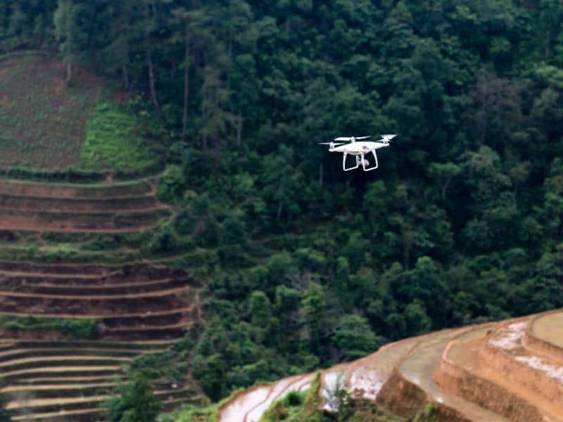
How LiDAR Builds a 3D Map of the Ground
LiDAR stands for Light Detection and Ranging. It works by shooting millions of rapid laser pulses down from a drone, airplane, or tripod and measuring exactly how long each pulse takes to bounce back.
Computers take these millions of measurements and turn them into a highly detailed 3D digital model of the land. This technology is incredibly useful for finding water issues for two main reasons:
- Extreme Precision: Traditional survey crews only measure specific points every few yards. LiDAR captures the entire surface. A tiny two-inch low spot that collects rainwater will pop out instantly on a LiDAR map.
- Virtual Raindrops: The digital model allows engineers to simulate exactly where water will flow. Instead of guessing based on a general slope, they can track the exact path a single raindrop would take from the highest hill to the lowest puddle.
Catching Bottlenecks Before Building
Fixing a drainage mistake after construction starts gets expensive very quickly. Builders use LiDAR during the planning stage long before any concrete is poured to catch mistakes on a computer screen where they cost nothing to fix.
If a planned parking lot or driveway is accidentally placed right in a natural water path, the LiDAR map reveals it immediately. The same goes for underground pipes and utilities. If trenches cross a natural path where water flows heavily, the soil can shift and cause underground pipes to crack over time.
Fixing Existing Properties
For land that is already developed, LiDAR data helps landowners make smart upgrades. Engineers use the maps to figure out:
- If underground drainage pipes (culverts) are too small.
- Where dirt has shifted over the years due to erosion.
- Where to dig ponds to hold extra rainwater.
Instead of guessing how much water a ditch needs to handle, engineers can calculate the exact size of the area draining into it. This means fixes are done right the first time.
Frequently Asked Questions
How does LiDAR find drainage problems?
It creates a highly accurate 3D map of the ground, exposing tiny dips, slopes, and paths where water naturally flows or pools.
Can LiDAR be used if the property has a lot of trees?
Yes! The laser pulses are able to find the small gaps between leaves and branches to hit the actual dirt below, giving a clear map of the “bare earth” beneath a thick forest.
Who benefits the most from this technology?
Ranchers, home builders, neighborhood developers, and everyday landowners who want to protect their roads, barns, and fields from water damage.
Is it better to map the land before or after building?
Before is always best. Finding a water problem on a map allows you to move a building or road before you spend money on construction.