
Why Elevation Certificates and LiDAR Mapping Work Together in Flood-Prone Areas
An elevation certificate tells you exactly how high a building sits above the floodplain. That’s all it tells you. It won’t explain why water gathers in one corner of the yard every spring while the other corner stays bone dry. It won’t show where the storm runoff is actually coming from. That gap is where LiDAR mapping comes in. For anyone dealing with flood risk, using both tools together paints a much fuller picture than either one alone.
People often lump these two services together because both deal with elevation, and both come up in flood conversations. But they don’t overlap as much as you’d think. One is a legal document tied to a single structure. The other is a terrain model covering the whole property. Once you see how they differ, it’s easy to understand why surveyors and homeowners end up needing both.
Understanding the Different Roles of Elevation Certificates and LiDAR Mapping
An elevation certificate is a formal document. A licensed surveyor or engineer prepares it. It records the exact height of a building’s lowest floor, along with other measurements tied to FEMA flood zone rules. Insurance companies use it to set flood insurance premiums. Local governments often require one before approving certain permits.
LiDAR mapping works on a different scale entirely. Instead of measuring one building, it captures elevation data across an entire parcel, sometimes hundreds of acres in a single pass. A plane or drone fires laser pulses at the ground and records where each one bounces back. Millions of these points get stitched into a detailed model. That model shows every slope, dip, and rise across the land.
The two tools answer different questions. An elevation certificate tells you whether your house meets flood compliance standards. LiDAR mapping tells you why water behaves the way it does on your land in the first place. Get only one, and you’re working with half the picture.
How LiDAR Mapping Reveals Water Flow Patterns Across Flood-Prone Land
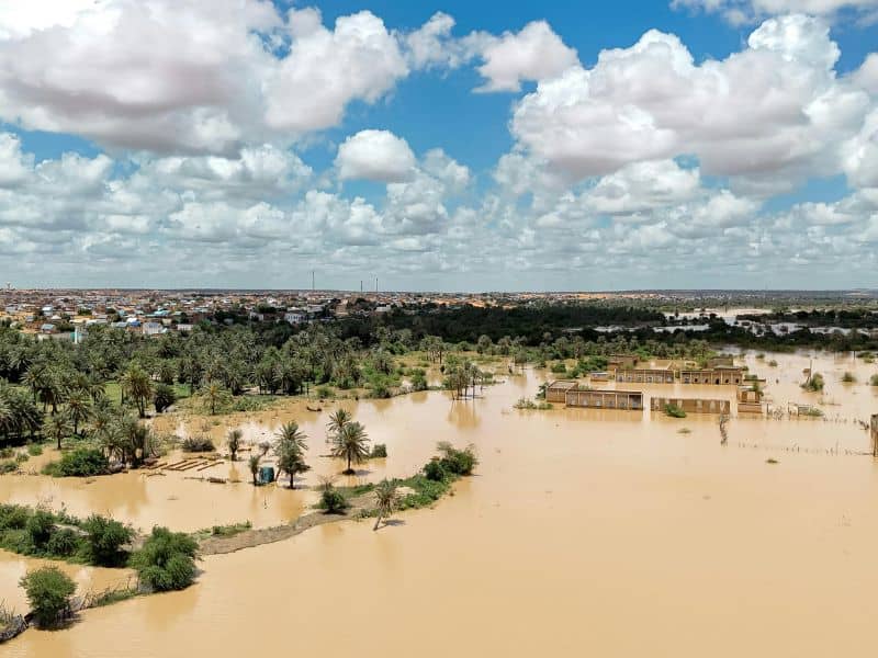
Flood-prone properties rarely flood the same way twice. That inconsistency usually comes down to terrain features nobody has ever mapped in detail. LiDAR data picks up subtle elevation changes that are nearly impossible to spot on foot. A two-foot grade change across a few hundred feet can completely change where water travels during a heavy rain. Most site visits never catch that kind of detail.
This matters because flood risk depends on more than just distance from a river or coastline. Natural channels, shallow depressions, and old drainage paths all shape how water moves once it shows up. LiDAR mapping catches these features clearly, even under grass, brush, or thin tree cover. A county flood map can show you a general risk zone. It won’t show you the specific low spot in your back field that fills up first, year after year.
For homeowners and developers working in these areas, that level of detail changes how they see the property. A lot that looks flat on a standard survey might actually have a natural channel running through it. That channel can quietly steer floodwater toward a structure for years without anyone noticing. Once it shows up on a LiDAR model, it stops being a mystery and starts being something you can plan around.
Why Accurate Ground Data Matters for Elevation Certificate Preparation
Surveyors preparing an elevation certificate need precise measurements. Good ground data makes that work more reliable. The certificate itself focuses on the structure. But understanding the land around that structure helps surveyors and owners make sense of the numbers once they’re in hand.
Detailed terrain information also helps owners ask sharper questions during the process. Say a homeowner already has a LiDAR model showing their lot sits in a slight bowl compared to the street. That context makes the certificate results much easier to interpret. It also helps when the conversation turns to insurance rates or floodplain status. An agent looking at a single number on a form doesn’t always tell the full story.
This pairing matters most for properties sitting near the edge of a flood zone boundary. Floodplain maps get drawn from broad elevation data. They don’t always catch small but important variations on a specific parcel. An owner who understands both the certificate results and the site’s actual terrain is in a much stronger position. They can question whether the flood zone designation really fits.
Planning Property Improvements With Both Surface Models and Elevation Information
Owners thinking about additions, detached garages, new driveways, or grading work benefit from checking both data sets before they break ground. An elevation certificate confirms where the existing structure stands relative to flood requirements. A LiDAR-based terrain model shows how a new addition or driveway might change water flow across the rest of the property.
This becomes especially important for anyone building in a low-lying area or adding hard surfaces like concrete or asphalt. A new driveway poured without checking the terrain model can block a natural drainage path. That can send water toward the house instead of away from it. Developers working larger parcels face the same risk at a bigger scale. One overlooked depression can throw off drainage for the entire site.
Checking both tools during planning, instead of after construction starts, leaves room to adjust while changes are still cheap. It also helps avoid a frustrating problem. A structure can technically meet every elevation certificate requirement and still flood, because the grading around it was never right. Compliance and real-world performance aren’t always the same thing.
Situations Where Property Owners May Need Both Services
A few situations call for both services at once. Someone buying land in a flood-prone area benefits from a full terrain picture before closing. A compliance document tied to whatever structure is already standing isn’t enough on its own. Developers evaluating large parcels need both the broad terrain model and accurate elevation paperwork for any existing buildings on site.
Insurance decisions also tend to pull in both. A homeowner trying to figure out why their flood premium jumped might find their elevation certificate looks perfectly fine. A LiDAR model can still reveal nearby terrain changes that quietly shifted their risk rating. Owners preparing for construction near a flood zone boundary often need both as well. Permits frequently demand an elevation certificate, while site planning depends on terrain analysis.
Even a simple property evaluation benefits from this pairing. Someone trying to understand why one part of their land floods and another stays dry needs more than a certificate. A LiDAR model gives a far clearer answer. The certificate was never built to explain how land behaves. It was built to document one number about one building.
Frequently Asked Questions
What is the difference between LiDAR mapping and an elevation certificate?
LiDAR mapping creates detailed terrain models that show the shape of the land. An elevation certificate documents specific building elevations used for flood insurance and floodplain-related purposes.
Can LiDAR mapping replace an elevation certificate?
No. LiDAR mapping and elevation certificates serve different functions. An elevation certificate must be prepared using survey measurements and follows specific FEMA requirements.
Why are both services useful in flood-prone areas?
Together, they provide a better understanding of both the land and the structure. This information can help with insurance, development planning, and property evaluations.
Who typically requests elevation certificates and LiDAR mapping?
Homeowners, buyers, lenders, developers, engineers, commercial property owners, and insurance professionals may request one or both services depending on the project.
Is LiDAR mapping helpful for large properties near flood zones?
Yes. LiDAR mapping provides detailed elevation information over large areas. This makes it easier to understand drainage patterns and terrain features that influence flood behavior.